Imådje:Rzeczpospolita Royal Ducal.png
I n’ a nén di pus grande finté.
Rzeczpospolita_Royal_Ducal.png (686 × 508 picsels, groxheur do fitchî: 144 Ko, del sôre "MIME": image/png)
Ci fitchî ci provént d’ Wikimedia Commons ; si pout i esse eployî divins des ôtes pordjets Wiki. Li discrijhaedje di si pådje di discrijhaedje låvå est håynêye cial ådzo.

|
Cette image (de type carte) devrait être recréée dans un format vectoriel, en tant que fichier SVG. Cela offrirait plusieurs avantages : voir Commons:Media for cleanup pour plus d'informations. Si une version SVG de cette image est déjà disponible, merci de bien vouloir l'envoyer. Après cela, remplacez ce modèle par {{vector version available|nouveau nom d'image.svg}}.
|
Discrijhaedje
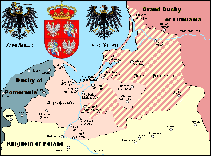
A Polish Wikipedian made version of Royal and Ducal Prussia around 1575.
Made by Halibutt in GIMP, based on an earlier GFDL map by w:User:Space Cadet and Halibutt's "Rzeczpospolita" map series.
| Kingdom of Poland | Since 1569 Polish-Lithuanian Commonwealth | |
| Grand Duchy of Lithuania | Since 1569 Polish-Lithuanian Commonwealth | |
| Royal Prussia | Pomeranian, Malbork, Chełmno Voivodships and bishopry of Warmia | |
| Ducal Prussia | Polish fief | |
| Duchy of Pomerania | Part of the Holy Roman Empire (since 1600s: "...of the German Nation") | |
| Brandenburg | Part of the Holy Roman Empire (since 1600s: "...of the German Nation") |

|
Des informations concernant cette image étaient incrustées dans l'image originale. Ces informations ont été déplacées dans les métadonnées et/ou la page de description de l'image. Ainsi, l'image est plus facilement réutilisable, l'information n'est pas restreinte à une langue particulière et il est plus facile de modifier ou rechercher l'information. Wikimedia Commons déconseille fortement l'incrustation visible d'informations dans les images. Toutes les licences acceptées sur Commons permettent les modifications du type de celles qui ont été effectuées ici, qui correspondent à la création d'une œuvre dérivée.
Si des informations regardant le droit d'auteur ont été enlevées et que l'image n'est pas dans le domaine public, remplacez ce modèle par {{Attribution metadata from licensed image}}.
|
Licince
Since the legal status of the above comment has been questioned, I hereby grant anyone the right to treat it as either a standard copyright notice, invariant section, legal statement, legal advice, friendly suggestion or a mere comment, depending on his or hers own choice. |
|

The following is a list of maps created by Halibutt and uploaded to commons, as well as their present and projected derivatives.
| Parent Image | Image | Description | |||||||||||
|---|---|---|---|---|---|---|---|---|---|---|---|---|---|
| Maps by Halibutt | |||||||||||||
| Image:Rzeczpospolita.png | Image:Rzeczpospolita.png | The Republic in 17th and 18th century | |||||||||||
| Image:Rzeczpospolita 1600.png | The Republic after the Treaty of Dywilino | ||||||||||||
| Image:Rzeczpospolita voivodships.png | Voivodships of The Republic | ||||||||||||
| Image:Rzeczpospolita_Potop.png | The Republic during The Deluge and Chmielnicki Uprising, with major battles of the era marked | ||||||||||||
| Magnates and their lands and domains | |||||||||||||
| 1st • 2nd • 3rd | Partitions of Poland | ||||||||||||
| War of the constitution | |||||||||||||
| Image:Rzeczpospolita.xcf | SOURCE FILE - GIMP format | ||||||||||||
| Image:Poland 1939.png | Image:Poland 1939.png | Poland in 1939 | |||||||||||
| Image:Dywizje wrzesien 1.png | Order of Battle on September 1st, during the Polish Defence War of 1939 | ||||||||||||
| Image:Poland 1939.xcf | SOURCE FILE - GIMP format | ||||||||||||
| Image:Polska kontur bialy.png | Image:Polska kontur bialy.png | Contour map of Poland AD 1999, for use with various locator maps | |||||||||||
| Image:Rzeczpospolita 1923.png | Image:Rzeczpospolita 1923.png | Map of Poland 1918-1939, currently under development | |||||||||||
| Image:PBW March 1919.png | Polish-Bolshevik War - fronts in March of 1919 | ||||||||||||
| Image:PBW December 1919.png | Polish-Bolshevik War - fronts in December of 1919 | ||||||||||||
| Image:PBW June 1920.png | Polish-Bolshevik War - fronts in July of 1920 | ||||||||||||
| Image:PBW August 1920.png | Polish-Bolshevik War - fronts in August of 1920 | ||||||||||||
| Polish Defence War of 1939 | |||||||||||||
| Polish areas annexed by Germany, Lithuania, Slovakia and the Soviet Union | |||||||||||||
| German concentration camps in Poland | |||||||||||||
| Curzon line | |||||||||||||
| Major battles of the Polish-Bolshevik War | |||||||||||||
| names • no names | Polish/Czechoslovak/Lithuanian/German/Ukrainian claims in 1920's | ||||||||||||
| Image:Rzeczpospolita Central Lithuania.png | Central Lithuania | ||||||||||||
| Image:Rzeczpospolita Lithuania claims.png | Central Lithuania as compared with other Lithuanian claims | ||||||||||||
| Image:Rzeczpospolita 1789-1920.png | Post-1922 borders compared with the territory of Poland before the partitions | ||||||||||||
| Warsaw Uprising and the Operation Tempest | |||||||||||||
| Poland partitioned between the Soviets and the Germans | |||||||||||||
| Image:Rzeczpospolita 1939 Polish divisions.png | Polish divisions on September 1, 1939 | ||||||||||||
| Home Army inspectorates | |||||||||||||
| Image:Rzeczpospolita 1922.xcf | SOURCE FILE - GIMP format | ||||||||||||
| Image:Rzeczpospolita 1937.svg | Vector version!!!! | layered version available on request | |||||||||||
Istwere do fitchî
Clitchîz so ene date ey ene eure po vey kimint ki l’ fitchî esteut adon.
| Date/Eure | Imådjete | Grandeur | Uzeu | Comintaire | |
|---|---|---|---|---|---|
| asteure | 3 avri 2023 à 12:44 | | 686 × 508 (144 Ko) | Natus37 | Wappenkorr. (-rote Flecke) |
| 19 fevrî 2013 à 21:30 |  | 686 × 508 (127 Ko) | Jbarta | remove caption, minor fix | |
| 28 fevrî 2006 à 16:27 |  | 686 × 534 (141 Ko) | Halibutt | A map of Royal and Ducal Prussia around 1575, made by Halibutt in GIMP, based on an [http://upload.wikimedia.org/wikipedia/en/archive/c/cb/20041019104150%21Royal_Ducal.png earlier GFDL map] by w:User:Space Cadet and Halibutt's "Rzeczpospolita" map se |
Eployaedjes do fitchî
Li pådje shuvante eploye ci fitchî ci :
Eployaedje tot avå do fitchî
Les ôtes shuvants wikis eployèt c’ fitchî ci :
- Eployaedje so an.wikipedia.org
- Eployaedje so ar.wikipedia.org
- Eployaedje so ast.wikipedia.org
- Eployaedje so az.wikipedia.org
- Eployaedje so be.wikipedia.org
- Eployaedje so ca.wikipedia.org
- Eployaedje so cs.wikipedia.org
- Eployaedje so da.wikipedia.org
- Eployaedje so de.wikipedia.org
- Eployaedje so el.wikipedia.org
- Eployaedje so en.wikipedia.org
- Eployaedje so eo.wikipedia.org
- Eployaedje so et.wikipedia.org
- Eployaedje so fi.wikipedia.org
- Eployaedje so fr.wikipedia.org
- Eployaedje so gl.wikipedia.org
- Eployaedje so he.wikipedia.org
- Eployaedje so hu.wikipedia.org
- Eployaedje so id.wikipedia.org
- Eployaedje so it.wikipedia.org
Loukîz di pus so l’ eployaedje totavå di ci fitchî ci.