Imådje:Map of Sealand with territorial waters.png

Fitchî d’ oridjinne(1 174 × 1 200 picsels, groxheur do fitchî: 55 Ko, del sôre "MIME": image/png)

Commons logo
Commons logo
Ci fitchî ci provént d’ Wikimedia Commons ; si pout i esse eployî divins des ôtes pordjets Wiki. Li discrijhaedje di si pådje di discrijhaedje låvå est håynêye cial ådzo.
Description

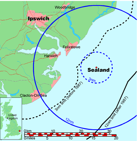
Map of Sealand

This is a map of the coast of England near Ipswich, showing the location of Sealand. The boundaries of the territorial water of the United Kingdom are also drawn, both the 3 nautical mile limit (5.556km) before 1987 and the 12nm limit (22.22km) after 1987. The same radii are also given around Sealand.

Note that these boundaries are derived based on the circular distance from the coastline, and not copied from official maps. This map is not suitable for navigation or for determining the boundaries of the UK territorial waters for legal or other purposes.

Créé par
Map generated by DEMIS World Map Server and edited by Chris 73
Otorijhaedje
(Reployaedje do fitchî)


Licensing:

This image was created by Chris 73. The image is licensed under a dual license; please choose either of the two licenses below as desired. Attribution to Wikipedia or another project of the Wikimedia foundation is required for both licenses if the image is used outside of projects of the Wikimedia foundation. Attribution to me is not required.

GNU head Vous avez la permission de copier, distribuer et modifier ce document selon les termes de la GNU Free Documentation License version 1.3 ou toute version ultérieure publiée par la Free Software Foundation, sans sections inaltérables, sans texte de première page de couverture et sans texte de dernière page de couverture. Un exemplaire de la licence est inclus dans la section intitulée GNU Free Documentation License.

w:fr:Creative Commons
atribucion pårtaedje a l’ idintike
Ci fitchî ci est rprindåve sorlon çou k’ est dit divins licence Creative Commons Atribouwaedje – Pårtaedje avou les minmes accoirds 3.0 (non transposée).
Vos estoz libe :
  • di pårtaedjî – di rcopyî, di rispåde eyet di rdiner cisse ouve ci
  • di rdjårber – di candjî ciste ouve
Avou les condicions ki shuvèt :
  • atribucion – Vos dvoz dner les racsegnes so l’ oteur ki vont bén, diner on loyén eviè l’ licince eyet mete si des candjmints ont stî fwaits. Vos ploz fé çoula di tote sôre di manires, mins nén tot djant ki l’ oteur vs aspale udonbén asprouve l’ uzaedje ki vos nd e fjhoz.
  • pårtaedje a l’ idintike – Si vs candjîz u si vs eployîz ciste ouve ci po dnè fé ene ôte, vos dvoz mete vost ovraedje dizo l’ minme licince u ene licince ki va avou l’ cene di l’ ouve d’ oridjinne.

"I want to use the image. How do I do that?"

You can use this image freely for any purpose, including commercial use, provided that you license it under one of the above licenses. My suggestion is to use the following text:

This Wikipedia and Wikimedia Commons image is from the user Chris 73 and is freely available at //commons.wikimedia.org/wiki/File:Map_of_Sealand_with_territorial_waters.png under the creative commons cc-by-sa 3.0 license.

For privacy reasons please use only "Chris 73" as author. If necessary, please translate the text in your language. For electronic use please include the links in the text as shown, for printed use please print the text as shown. If you use the image I would appreciate it if you would let me know on my talk page, but this is not required as long as you follow one of the above licenses.


 Données géotemporelles
Rectangle englobant
N: 52.1374339°N
W: 0.9973602°E E: 1.6619722°E
S: 51.6274989°N
Géoréférencement Voir la carte géoréférencée dans Wikimaps Warper

Légendes

Ajoutez en une ligne la description de ce que représente ce fichier

Éléments décrits dans ce fichier

mostere

type MIME français

image/png

845a9e08cbe7ed93bae6eeabe454399a76e3324f

méthode de détermination français : SHA-1 français

56 131 octet

hauteur français

1 200 picsel

largeur français

1 174 picsel

Istwere do fitchî

Clitchîz so ene date ey ene eure po vey kimint ki l’ fitchî esteut adon.

Date/EureImådjeteGrandeurUzeuComintaire
asteure9 djulete 2006 à 19:41Imådjete pol modêye do 9 djulete 2006 à 19:411 174 × 1 200 (55 Ko)Chris 73update
26 djanvî 2005 à 10:00Imådjete pol modêye do 26 djanvî 2005 à 10:001 024 × 1 046 (50 Ko)Chris 73

Li pådje shuvante eploye ci fitchî ci :

Eployaedje tot avå do fitchî

Les ôtes shuvants wikis eployèt c’ fitchî ci :