Imådje:Map Crusader states 1135-en.svg

Taille de cet aperçu PNG pour ce fichier SVG : 435 × 599 picsels. Ôtès fintés: 174 × 240 picsels | 348 × 480 picsels | 558 × 768 picsels | 744 × 1 024 picsels | 1 487 × 2 048 picsels | 955 × 1 315 picsels.
Fitchî d’ oridjinne (Fitchî SVG, finté di 955 × 1 315 picsels, grandeu: 418 Ko)
Ci fitchî ci provént d’ Wikimedia Commons ; si pout i esse eployî divins des ôtes pordjets Wiki. Li discrijhaedje di si pådje di discrijhaedje låvå est håynêye cial ådzo.
Discrijhaedje
| Discrijhaedje |
[]
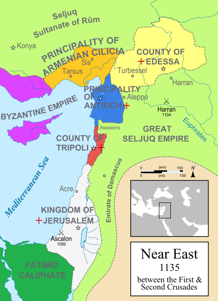
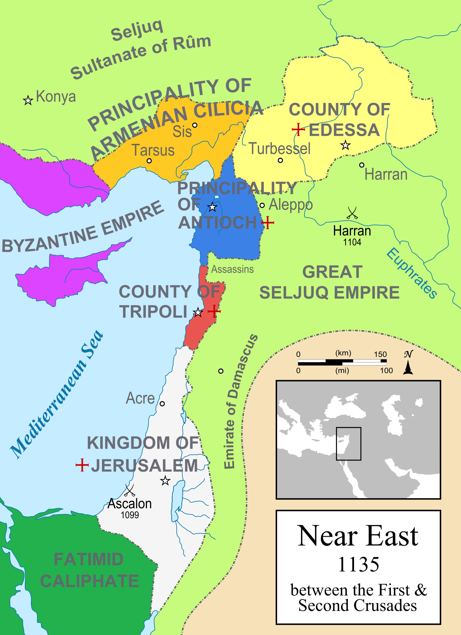
Čeština: Politická mapa Blízkého východu v roce 1135. Deutsch: Die Levante, 1135, zwischen den Ersten und Zweiten Kreuzzügen. Kreuzzugsstaaten sind mit einem roten Kreuz gekennzeichnet Eesti: Lähis-Ida (1135) Español: Oriente Próximo en 1135, entre la primera y segunda cruzadas. Esperanto: Politika mapo de Levantenio dum 1135, inter la krucmilitaroj unuaj kaj duaj. Français : Carte politique du Proche-Orient en 1135, entre la Première et la Seconde Croisades. les États latins d'Orient sont marqués d'une croix rouge. Italiano: Carta politica del Vicino Oriente nel 1135. Magyar: A Közel-Kelet térképe 1135-ben. Polski: Mapa polityczna Bliskiego Wschodu w roku 1135, w okresie II krucjaty. Ελληνικά: Πολιτικός χάρτης της Μέσης Ανατολής το 1135, ανάμεσα στην πρώτη και τη δεύτερη Σταυροφορία Македонски: Политичка карта на Блискиот Исток во 1135 г. Крстоносните држави се означени со црвени крстови. Русский: Карта Ближнего Востока в 1135 г. Српски / srpski: Politička karta Bliskog Istoka 1135. godine, između Prvog i Drugog krstaškog pohoda. Krstaške države su označene crvenim krstom. ქართული: ახლო აღმოსავლეთი 1135 წელს ไทย: แผนที่ตะวันออกกลาง (คศ. 1135) ระหว่างครูเสดครั้งที่ 1 และครั่งที่ 2 中文: 一副关于1135年近东地区局势的地图,标注红色十字的为十字军国家 العربية : الدويلات الصليبية والدول الإسلامية المجاورة لها في الفترة بين الحملتين الصليبيتين الأولى والثانية. فارسی : نسخه فارسی |
||
| Sourdant | Prôpe ovraedje | ||
| Oteur | MapMaster | ||
| Ôtès modêyes |
[]
See also |
||
| SVG information |


-ka.png)


References
- Bjorklund, Oddvar; Holmboe, Haakon; Rohr, Anders (1970) Historical Atlas of the World, Barnes & Noble, NY, SBN: 389-00253-4.
- Asia Minor and the Crusader states, c. 1140 from Findlay, Alexander G. (1849) Classical Atlas of Ancient Geography.
- Map of the Crusader states from Muir's Historical Atlas (1911)
Licince
Moi, en tant que détenteur des droits d’auteur sur cette œuvre, je la publie sous la licence suivante :

|
Vos avoz l’ droet di rcopyî, di spåde et di rcandjî ci documint ci sorlon çou k’ est di dins l’ GNU Free Documentation License modêye 1.2 u les cenes d’ après eplaidêyes pal Free Software Foundation, sins hagnons nén candjåves, sins l’ tecse del prumire pådje di coviete eyet sins l’ tecse del dierinne pådje di coviete. Gn a-st on egzimpe del licince divins li hagnon k’ a l’ tite GNU Free Documentation License. |
| Ci fitchî ci est rprindåve sorlon çou k’ est dit divins licence Creative Commons Atribouwaedje – Pårtaedje avou les minmes accoirds 3.0 (non transposée). | ||
| ||
| Ce bandeau de licence a été ajouté à ce fichier dans le cadre de la procédure de mise à jour des licences des images sous GFDL. |
derivative works
Œuvres dérivées de ce fichier :
- Map Crusader states 1135-ar.png
- Map Crusader states 1135-es.svg
- Map Crusader states 1135-zh.svg
- Map Crusader states 1135-es2.svg
Istwere do fitchî
Clitchîz so ene date ey ene eure po vey kimint ki l’ fitchî esteut adon.
| Date/Eure | Imådjete | Grandeur | Uzeu | Comintaire | |
|---|---|---|---|---|---|
| asteure | 19 måss 2015 à 21:01 | | 955 × 1 315 (418 Ko) | Denniss | Reverted to version as of 09:13, 25 July 2012 |
| 19 måss 2015 à 13:03 |  | 955 × 1 315 (433 Ko) | Dorudgar | Translation from English to Arabic الترجمة من الإنگليزية إلى العربية | |
| 25 djulete 2012 à 09:13 |  | 955 × 1 315 (418 Ko) | HorsefaCe | Cilicia wan't a kingdom yet | |
| 25 djulete 2012 à 09:08 |  | 955 × 1 315 (120 Ko) | HorsefaCe | A Chinese version. | |
| 12 djulete 2010 à 11:48 |  | 955 × 1 315 (418 Ko) | Malus Catulus | Cilicia wan't a kingdom yet | |
| 12 djulete 2010 à 10:59 |  | 955 × 1 315 (424 Ko) | Malus Catulus | Corrected burid dynasty | |
| 11 djulete 2010 à 22:01 |  | 955 × 1 315 (418 Ko) | Malus Catulus | Final tweaks | |
| 11 djulete 2010 à 21:52 |  | 955 × 1 315 (403 Ko) | Malus Catulus | Now complies with w3c so I hope the box is gone | |
| 11 djulete 2010 à 21:22 |  | 955 × 1 315 (403 Ko) | Malus Catulus | Trying to remove black box | |
| 11 djulete 2010 à 21:18 |  | 955 × 1 315 (402 Ko) | Malus Catulus | Forgot to convert Med. sea and Euphrates to path |
Eployaedjes do fitchî
Li pådje shuvante eploye ci fitchî ci :
Eployaedje tot avå do fitchî
Les ôtes shuvants wikis eployèt c’ fitchî ci :
- Eployaedje so an.wikipedia.org
- Eployaedje so ar.wikipedia.org
- Eployaedje so arz.wikipedia.org
- Eployaedje so ast.wikipedia.org
- Eployaedje so azb.wikipedia.org
- Eployaedje so az.wikipedia.org
- Eployaedje so ba.wikipedia.org
- Eployaedje so be.wikipedia.org
- Eployaedje so bg.wikipedia.org
- Eployaedje so bn.wikipedia.org
- Eployaedje so br.wikipedia.org
- Eployaedje so bxr.wikipedia.org
- Eployaedje so ckb.wikipedia.org
- Eployaedje so cs.wikipedia.org
- Eployaedje so cy.wikipedia.org
- Eployaedje so da.wikipedia.org
Loukîz di pus so l’ eployaedje totavå di ci fitchî ci.