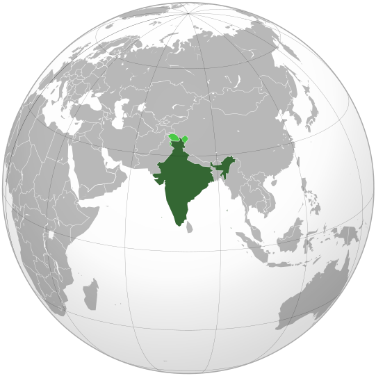
Fitchî d’ oridjinne(Fitchî SVG, finté di 541 × 541 picsels, grandeu: 280 Ko)

Commons logo
Commons logo
Ci fitchî ci provént d’ Wikimedia Commons ; si pout i esse eployî divins des ôtes pordjets Wiki. Li discrijhaedje di si pådje di discrijhaedje låvå est håynêye cial ådzo.

Discrijhaedje

Discrijhaedje
English: India. Area controlled by India in dark green; claimed but not controlled areas in light green.
Date
Sourdant

Own work,

 
Cette image vectorielle a été créée avec Inkscape .

Aquarius.geomar.de

বাংলা  English  español  français  italiano  日本語  македонски  sicilianu  中文(简体)  中文(繁體)  +/−

GNU head Vos avoz l’ droet di rcopyî, di spåde et di rcandjî ci documint ci sorlon çou k’ est di dins l’ GNU Free Documentation License modêye 1.2 u les cenes d’ après eplaidêyes pal Free Software Foundation, sins hagnons nén candjåves, sins l’ tecse del prumire pådje di coviete eyet sins l’ tecse del dierinne pådje di coviete. Gn a-st on egzimpe del licince divins li hagnon k’ a l’ tite GNU Free Documentation License.
Oteur Ssolbergj (talk)
Ôtès modêyes

Œuvres dérivées de ce fichier :

This is a Grey & green orthographic projection map.
العربية: الرجاء، قراءة الميثاق.
বাংলা: দয়া করে, রীতিনীতিটি পড়ুন
Deutsch: Bitte lies die Konventionen.
English: Please, read the conventions.
Español: Por favor, lea las convenciones.
Filipino: Paki-basa ang mga kumbensyon.
Français : S'il vous plaît, lisez les conventions.
हिन्दी: कृपया सभागमों को पढ़ लें.
Bahasa Indonesia: Silakan, baca konvensi.
Italiano: Si prega di leggere le convenzioni.
ქართული: გთხოვთ, გაეცნოთ კონვენციებს.
Português: Por favor, leia as convenções.
Русский: Пожалуйста, прочитайте соглашения.
Українська: Будь ласка, прочитайте конвенції.
Tiếng Việt: Hãy đọc công văn trước khi đăng.
World maps

Africa

हिन्दी: अफ्रीका
ქართული: აფრიკა.

Eastern Africa

Southern Africa

Central Africa

Northern Africa

Western Africa

Americas

ქართული: ამერიკა.
हिन्दी: अमेरिका

North America

Central America

Caribbean

South America

Asia

ქართული: აზია.
Português: Ásia.
Українська: Азія.

East

Português: Ásia Oriental.
Українська: Східна Азія.

Central

हिन्दी: मध्य एशिया
Português: Ásia Central.
Українська: Центральна Азія.

Southeast

Bahasa Indonesia: Asia tenggara
Português: Sudeste Asiático.

South

(भारतीय उपमहाद्वीप)
Português: Sul da Ásia.
Українська: Південна Азія.

Western

Português: Sudoeste da Ásia.
Українська: Передня Азія.

Europe

हिन्दी: यूरोप
ქართული: ევროპა.
Português: Europa.
Română: Europa.
Русский: Европа.
Українська: Європа.

Countries

Oceania

हिन्दी: ओशिआनिया
ქართული: ოკეანეთი.
Português: Oceania.
Українська: Океанія.

Intercontinental

Português: Intercontinental.
Українська: Міжконтинентальні.

Historical

English: Unions, Organizations, Kingdoms, Empires
Español: Uniones, Organizaciones, Reinos, Imperios
Filipino: Mga Unyon, Organisasyon, Kaharian, Imperyo
Français : Unions, Organisations, Royaumes, Empires
हिन्दी: संघ, संगठन, राज्य, साम्राज्य व ऐतिहासिक देश
ქართული: გაერთიანებები, ორგანიზაციები, სამეფოები, იმპერიები
Português: Estados extintos.
Tagalog: Mga Unyon, Organisasyon, Kaharian, Imperyo
Українська: Союзи, Організації, Королівства, Імперії

Subnationals

हिन्दी: उपराष्ट्रीय इकाईयाँ
Orthographic projections maps created by Ssolbergj
Orthographic projections maps created by Ssolbergj:

Licince

GNU head Vos avoz l’ droet di rcopyî, di spåde et di rcandjî ci documint ci sorlon çou k’ est di dins l’ GNU Free Documentation License modêye 1.2 u les cenes d’ après eplaidêyes pal Free Software Foundation, sins hagnons nén candjåves, sins l’ tecse del prumire pådje di coviete eyet sins l’ tecse del dierinne pådje di coviete. Gn a-st on egzimpe del licince divins li hagnon k’ a l’ tite GNU Free Documentation License.
w:fr:Creative Commons
atribucion pårtaedje a l’ idintike
Ci fitchî ci est rprindåve sorlon çou k’ est dit divins licence Creative Commons Atribouwaedje – Pårtaedje avou les minmes accoirds 3.0 (non transposée).
Vos estoz libe :
  • di pårtaedjî – di rcopyî, di rispåde eyet di rdiner cisse ouve ci
  • di rdjårber – di candjî ciste ouve
Avou les condicions ki shuvèt :
  • atribucion – Vos dvoz dner les racsegnes so l’ oteur ki vont bén, diner on loyén eviè l’ licince eyet mete si des candjmints ont stî fwaits. Vos ploz fé çoula di tote sôre di manires, mins nén tot djant ki l’ oteur vs aspale udonbén asprouve l’ uzaedje ki vos nd e fjhoz.
  • pårtaedje a l’ idintike – Si vs candjîz u si vs eployîz ciste ouve ci po dnè fé ene ôte, vos dvoz mete vost ovraedje dizo l’ minme licince u ene licince ki va avou l’ cene di l’ ouve d’ oridjinne.
{{{template}}} Warning! According to Indian law, it is illegal to produce maps that in the view of the Indian government, misrepresent Indian territories by showing areas the Indian government claims ownership of but does not control as not belonging to India or as being contested.

Légendes

Ajoutez en une ligne la description de ce que représente ce fichier
india

Éléments décrits dans ce fichier

mostere

créé par français

Valeur sans élément de Wikidata

nôvimbe 2008

type MIME français

image/svg+xml

Istwere do fitchî

Clitchîz so ene date ey ene eure po vey kimint ki l’ fitchî esteut adon.

(les dierins | les pus vîs) Vey (10 pus noveas | ) (10 | 20 | 50 | 100 | 250 | 500).
Date/EureImådjeteGrandeurUzeuComintaire
asteure26 avri 2023 à 07:10Imådjete pol modêye do 26 avri 2023 à 07:10541 × 541 (280 Ko)Swtadi143Reverted to version as of 07:34, 16 September 2021 (UTC) siachen glacier is fully controlled by india and not india pakistan jointly, see Siachen conflict for context.
20 setimbe 2021 à 10:02Imådjete pol modêye do 20 setimbe 2021 à 10:02512 × 512 (155 Ko)Ytpks896Reverted to version as of 17:38, 6 September 2021 (UTC) Siachen is a disputed territory not fully controlled by single country it is controlled by both Pakistan and india & some parts by china
16 setimbe 2021 à 07:34Imådjete pol modêye do 16 setimbe 2021 à 07:34541 × 541 (280 Ko)Ksh.andronexusReverted to version as of 16:08, 19 December 2019 (UTC)
6 setimbe 2021 à 17:38Imådjete pol modêye do 6 setimbe 2021 à 17:38512 × 512 (155 Ko)MilenioscuroSiachen is a disputed territory between China, India and Pakistan
19 decimbe 2019 à 16:08Imådjete pol modêye do 19 decimbe 2019 à 16:08541 × 541 (280 Ko)Goran tek-enAdded border for South Sudan as requested by {{u|Maphobbyist}}
21 octôbe 2017 à 14:04Imådjete pol modêye do 21 octôbe 2017 à 14:04541 × 541 (139 Ko)Goran tek-enAdded Siachen Glacier as requested by {{u|King Prithviraj II}}
12 setimbe 2012 à 21:31Imådjete pol modêye do 12 setimbe 2012 à 21:31541 × 541 (167 Ko)PalosirkkaScrubbed with http://codedread.com/scour/
15 nôvimbe 2009 à 23:40Imådjete pol modêye do 15 nôvimbe 2009 à 23:40541 × 541 (573 Ko)Shibo77+Eritrea, Yemen; -neutral zone
1 nôvimbe 2009 à 13:18Imådjete pol modêye do 1 nôvimbe 2009 à 13:18541 × 541 (496 Ko)Pahari SahibMap showing territory governered by India, see map of Pakistan
11 måss 2009 à 13:17Imådjete pol modêye do 11 måss 2009 à 13:17541 × 541 (572 Ko)TryphonReverted to version as of 22:12, 13 February 2009: please use the talk page before reverting this image; there are apparently many people who want the map this way.
(les dierins | les pus vîs) Vey (10 pus noveas | ) (10 | 20 | 50 | 100 | 250 | 500).

Li pådje shuvante eploye ci fitchî ci :

Eployaedje tot avå do fitchî

Les ôtes shuvants wikis eployèt c’ fitchî ci :

Loukîz di pus so l’ eployaedje totavå di ci fitchî ci.

Meta-dnêyes